Talsperrensteuerzentrale
Stauanlage TS Radeburg I
Letzte Aktualisierung der Webseite: 02.05.2024 18:00 Uhr (MESZ)
Allgemeine Angaben:
Gewässer: Große Röder
Flusseinzugsgebiet: Oberes Elbtal
Einzugsgebietsgröße: 303,423 km²
Naturraum: Sächsisches Hügelland
Nächstgelegene Stadt: Radeburg
Zuflusspegel Zufluss berechnet
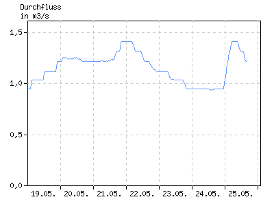
Durchfluss in m³/s
| 01:00 | 04:00 | 07:00 | 10:00 | 13:00 | 16:00 | 19:00 | 22:00 | |
|---|---|---|---|---|---|---|---|---|
| 26.04. | 1,603 | 1,603 | 1,603 | 1,603 | 1,589 | 1,515 | 1,510 | 1,574 |
| 27.04. | 1,597 | 1,505 | 1,503 | 1,503 | 1,497 | 1,439 | 1,405 | 1,403 |
| 28.04. | 1,404 | 1,403 | 1,403 | 1,403 | 1,404 | 1,404 | 1,403 | 1,403 |
| 29.04. | 1,403 | 1,403 | 1,403 | 1,403 | 1,330 | 1,320 | 1,313 | 1,317 |
| 30.04. | 1,401 | 1,374 | 1,330 | 1,322 | 1,225 | 1,215 | 1,213 | 1,213 |
| 01.05. | 1,212 | 1,200 | 1,149 | 1,120 | 1,112 | 1,103 | 1,043 | 1,047 |
| 02.05. | 1,047 | 1,071 | 1,078 | 1,066 | 1,060 | 1,037 | k.A. | k.A. |
Abgabepegel

Durchfluss in m³/s
| 01:00 | 04:00 | 07:00 | 10:00 | 13:00 | 16:00 | 19:00 | 22:00 | |
|---|---|---|---|---|---|---|---|---|
| 26.04. | 1,570 | 1,570 | 1,570 | 1,570 | 1,556 | 1,482 | 1,477 | 1,541 |
| 27.04. | 1,564 | 1,472 | 1,470 | 1,470 | 1,464 | 1,406 | 1,372 | 1,370 |
| 28.04. | 1,371 | 1,370 | 1,370 | 1,370 | 1,371 | 1,371 | 1,370 | 1,370 |
| 29.04. | 1,370 | 1,370 | 1,370 | 1,370 | 1,297 | 1,287 | 1,280 | 1,284 |
| 30.04. | 1,368 | 1,341 | 1,297 | 1,289 | 1,192 | 1,182 | 1,180 | 1,180 |
| 01.05. | 1,179 | 1,167 | 1,116 | 1,087 | 1,079 | 1,070 | 1,010 | 1,014 |
| 02.05. | 1,014 | 1,038 | 1,045 | 1,033 | 1,027 | 1,004 | k.A. | k.A. |
Stauanlage
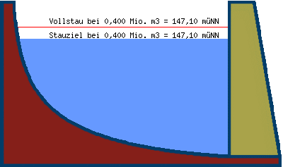
| Teilstauraum | Staulamelle einzeln [Mio. m³] |
Stauinhalt summarisch [Mio. m³] |
|---|---|---|
| Totraum | 0,000 | 0,000 |
| Reserveraum | 0,250 | 0,250 |
| Betriebsraum | 0,150 | 0,400 |
| gewöhnlicher Hochwasser- rückhalteraum |
0,000 | 0,400 |
Beckeninhalt in Mio m³
| 01:00 | 04:00 | 07:00 | 10:00 | 13:00 | 16:00 | 19:00 | 22:00 | |
|---|---|---|---|---|---|---|---|---|
| 26.04. | 0,385 | 0,385 | 0,385 | 0,385 | 0,385 | 0,383 | 0,382 | 0,384 |
| 27.04. | 0,385 | 0,382 | 0,382 | 0,382 | 0,382 | 0,380 | 0,379 | 0,379 |
| 28.04. | 0,379 | 0,379 | 0,379 | 0,379 | 0,379 | 0,379 | 0,379 | 0,379 |
| 29.04. | 0,379 | 0,379 | 0,379 | 0,379 | 0,377 | 0,376 | 0,376 | 0,376 |
| 30.04. | 0,379 | 0,379 | 0,377 | 0,376 | 0,373 | 0,373 | 0,373 | 0,373 |
| 01.05. | 0,373 | 0,373 | 0,371 | 0,370 | 0,370 | 0,370 | 0,368 | 0,368 |
| 02.05. | 0,368 | 0,369 | 0,369 | 0,368 | 0,368 | 0,367 | k.A. | k.A. |
Wasserstand in müNN
| 01:00 | 04:00 | 07:00 | 10:00 | 13:00 | 16:00 | 19:00 | 22:00 | |
|---|---|---|---|---|---|---|---|---|
| 26.04. | 147,05 | 147,05 | 147,05 | 147,05 | 147,05 | 147,04 | 147,04 | 147,05 |
| 27.04. | 147,05 | 147,04 | 147,04 | 147,04 | 147,04 | 147,03 | 147,03 | 147,03 |
| 28.04. | 147,03 | 147,03 | 147,03 | 147,03 | 147,03 | 147,03 | 147,03 | 147,03 |
| 29.04. | 147,03 | 147,03 | 147,03 | 147,03 | 147,02 | 147,02 | 147,02 | 147,02 |
| 30.04. | 147,03 | 147,03 | 147,02 | 147,02 | 147,01 | 147,01 | 147,01 | 147,01 |
| 01.05. | 147,01 | 147,01 | 147,00 | 147,00 | 147,00 | 147,00 | 146,99 | 146,99 |
| 02.05. | 146,99 | 147,00 | 147,00 | 146,99 | 146,99 | 146,99 | k.A. | k.A. |