Talsperrensteuerzentrale
Stauanlage TS Radeburg I
Letzte Aktualisierung der Webseite: 20.04.2024 06:15 Uhr (MESZ)
Allgemeine Angaben:
Gewässer: Große Röder
Flusseinzugsgebiet: Oberes Elbtal
Einzugsgebietsgröße: 303,423 km²
Naturraum: Sächsisches Hügelland
Nächstgelegene Stadt: Radeburg
Zuflusspegel Zufluss berechnet
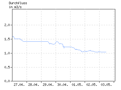
Durchfluss in m³/s
| 01:00 | 04:00 | 07:00 | 10:00 | 13:00 | 16:00 | 19:00 | 22:00 | |
|---|---|---|---|---|---|---|---|---|
| 14.04. | 1,603 | 1,604 | 1,603 | 1,565 | 1,510 | 1,503 | 1,505 | 1,506 |
| 15.04. | 1,509 | 1,505 | 1,513 | 1,603 | 1,603 | 1,713 | 1,717 | 1,817 |
| 16.04. | 1,804 | 1,803 | 1,713 | 1,704 | 1,634 | 1,604 | 1,604 | 1,604 |
| 17.04. | 1,614 | 1,713 | 1,713 | 1,702 | 1,611 | 1,605 | 1,603 | 1,603 |
| 18.04. | 1,603 | 1,603 | 1,603 | 1,594 | 1,504 | 1,503 | 1,503 | 1,503 |
| 19.04. | 1,503 | 1,503 | 1,504 | 1,501 | 1,501 | 1,503 | 1,592 | 1,603 |
| 20.04. | 1,823 | 1,943 | k.A. | k.A. | k.A. | k.A. | k.A. | k.A. |
Abgabepegel
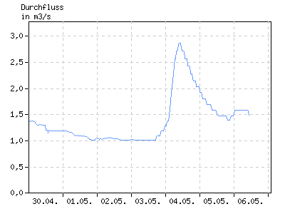
Durchfluss in m³/s
| 01:00 | 04:00 | 07:00 | 10:00 | 13:00 | 16:00 | 19:00 | 22:00 | |
|---|---|---|---|---|---|---|---|---|
| 14.04. | 1,570 | 1,571 | 1,570 | 1,532 | 1,477 | 1,470 | 1,472 | 1,473 |
| 15.04. | 1,476 | 1,472 | 1,480 | 1,570 | 1,570 | 1,680 | 1,684 | 1,784 |
| 16.04. | 1,771 | 1,770 | 1,680 | 1,671 | 1,601 | 1,571 | 1,571 | 1,571 |
| 17.04. | 1,581 | 1,680 | 1,680 | 1,669 | 1,578 | 1,572 | 1,570 | 1,570 |
| 18.04. | 1,570 | 1,570 | 1,570 | 1,561 | 1,471 | 1,470 | 1,470 | 1,470 |
| 19.04. | 1,470 | 1,470 | 1,471 | 1,468 | 1,468 | 1,470 | 1,559 | 1,570 |
| 20.04. | 1,790 | 1,910 | k.A. | k.A. | k.A. | k.A. | k.A. | k.A. |
Stauanlage
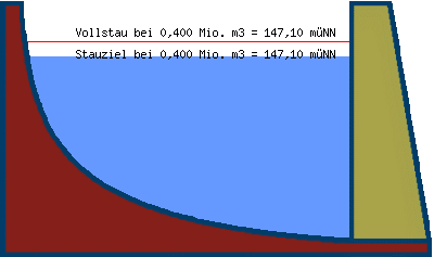
| Teilstauraum | Staulamelle einzeln [Mio. m³] |
Stauinhalt summarisch [Mio. m³] |
|---|---|---|
| Totraum | 0,000 | 0,000 |
| Reserveraum | 0,250 | 0,250 |
| Betriebsraum | 0,150 | 0,400 |
| gewöhnlicher Hochwasser- rückhalteraum |
0,000 | 0,400 |
Beckeninhalt in Mio m³
| 01:00 | 04:00 | 07:00 | 10:00 | 13:00 | 16:00 | 19:00 | 22:00 | |
|---|---|---|---|---|---|---|---|---|
| 14.04. | 0,385 | 0,385 | 0,385 | 0,384 | 0,382 | 0,382 | 0,382 | 0,382 |
| 15.04. | 0,382 | 0,382 | 0,383 | 0,385 | 0,385 | 0,388 | 0,388 | 0,391 |
| 16.04. | 0,391 | 0,391 | 0,388 | 0,388 | 0,386 | 0,385 | 0,385 | 0,385 |
| 17.04. | 0,385 | 0,388 | 0,388 | 0,388 | 0,385 | 0,385 | 0,385 | 0,385 |
| 18.04. | 0,385 | 0,385 | 0,385 | 0,385 | 0,382 | 0,382 | 0,382 | 0,382 |
| 19.04. | 0,382 | 0,382 | 0,382 | 0,382 | 0,382 | 0,382 | 0,385 | 0,385 |
| 20.04. | 0,391 | 0,394 | k.A. | k.A. | k.A. | k.A. | k.A. | k.A. |
Wasserstand in müNN
| 01:00 | 04:00 | 07:00 | 10:00 | 13:00 | 16:00 | 19:00 | 22:00 | |
|---|---|---|---|---|---|---|---|---|
| 14.04. | 147,05 | 147,05 | 147,05 | 147,05 | 147,04 | 147,04 | 147,04 | 147,04 |
| 15.04. | 147,04 | 147,04 | 147,04 | 147,05 | 147,05 | 147,06 | 147,06 | 147,07 |
| 16.04. | 147,07 | 147,07 | 147,06 | 147,06 | 147,05 | 147,05 | 147,05 | 147,05 |
| 17.04. | 147,05 | 147,06 | 147,06 | 147,06 | 147,05 | 147,05 | 147,05 | 147,05 |
| 18.04. | 147,05 | 147,05 | 147,05 | 147,05 | 147,04 | 147,04 | 147,04 | 147,04 |
| 19.04. | 147,04 | 147,04 | 147,04 | 147,04 | 147,04 | 147,04 | 147,05 | 147,05 |
| 20.04. | 147,07 | 147,08 | k.A. | k.A. | k.A. | k.A. | k.A. | k.A. |