Talsperrensteuerzentrale
Stauanlage TS Döllnitzsee
Letzte Aktualisierung der Webseite: 19.04.2024 09:15 Uhr (MESZ)
Allgemeine Angaben:
Gewässer:
Flusseinzugsgebiet: Elbaue / Mulde / Untere Weiße Elster
Einzugsgebietsgröße: 22,600 km²
Naturraum:
Nächstgelegene Stadt:
Abgabepegel
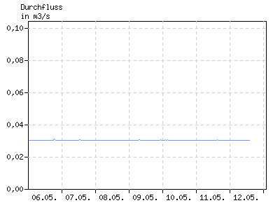
Durchfluss in m³/s
| 01:00 | 04:00 | 07:00 | 10:00 | 13:00 | 16:00 | 19:00 | 22:00 | |
|---|---|---|---|---|---|---|---|---|
| 13.04. | 0,031 | 0,031 | 0,030 | 0,030 | 0,030 | 0,030 | 0,031 | 0,030 |
| 14.04. | 0,031 | 0,031 | 0,031 | 0,030 | 0,030 | 0,031 | 0,031 | 0,031 |
| 15.04. | 0,030 | 0,030 | 0,030 | 0,030 | 0,030 | 0,031 | 0,030 | 0,040 |
| 16.04. | 0,030 | 0,030 | 0,030 | 0,030 | 0,030 | 0,030 | 0,030 | 0,030 |
| 17.04. | 0,030 | 0,030 | 0,030 | 0,030 | 0,030 | 0,030 | 0,030 | 0,030 |
| 18.04. | 0,030 | 0,030 | 0,030 | 0,030 | 0,030 | 0,030 | 0,030 | 0,030 |
| 19.04. | 0,030 | 0,030 | 0,031 | k.A. | k.A. | k.A. | k.A. | k.A. |
Stauanlage
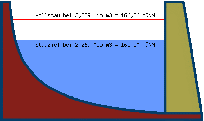
| Teilstauraum | Staulamelle einzeln [Mio. m³] |
Stauinhalt summarisch [Mio. m³] |
|---|---|---|
| Totraum | 0,000 | 0,000 |
| Reserveraum | k.A. | k.A. |
| Betriebsraum | 2,269 | 2,269 |
| gewöhnlicher Hochwasser- rückhalteraum |
0,620 | 2,889 |
Beckeninhalt in Mio m³
| 01:00 | 04:00 | 07:00 | 10:00 | 13:00 | 16:00 | 19:00 | 22:00 | |
|---|---|---|---|---|---|---|---|---|
| 13.04. | 2,248 | 2,248 | 2,248 | 2,248 | 2,248 | 2,247 | 2,246 | 2,247 |
| 14.04. | 2,247 | 2,247 | 2,247 | 2,248 | 2,247 | 2,247 | 2,246 | 2,245 |
| 15.04. | 2,246 | 2,247 | 2,249 | 2,249 | 2,249 | 2,249 | 2,249 | 2,255 |
| 16.04. | 2,252 | 2,251 | 2,251 | 2,252 | 2,251 | 2,251 | 2,251 | 2,251 |
| 17.04. | 2,251 | 2,251 | 2,252 | 2,251 | 2,252 | 2,252 | 2,251 | 2,251 |
| 18.04. | 2,251 | 2,251 | 2,251 | 2,250 | 2,250 | 2,251 | 2,251 | 2,251 |
| 19.04. | 2,251 | 2,252 | 2,252 | k.A. | k.A. | k.A. | k.A. | k.A. |
Wasserstand in müNN
| 01:00 | 04:00 | 07:00 | 10:00 | 13:00 | 16:00 | 19:00 | 22:00 | |
|---|---|---|---|---|---|---|---|---|
| 13.04. | 165,47 | 165,47 | 165,47 | 165,47 | 165,47 | 165,47 | 165,47 | 165,47 |
| 14.04. | 165,47 | 165,47 | 165,47 | 165,47 | 165,47 | 165,47 | 165,47 | 165,47 |
| 15.04. | 165,47 | 165,47 | 165,48 | 165,48 | 165,48 | 165,48 | 165,47 | 165,48 |
| 16.04. | 165,48 | 165,48 | 165,48 | 165,48 | 165,48 | 165,48 | 165,48 | 165,48 |
| 17.04. | 165,48 | 165,48 | 165,48 | 165,48 | 165,48 | 165,48 | 165,48 | 165,48 |
| 18.04. | 165,48 | 165,48 | 165,48 | 165,48 | 165,48 | 165,48 | 165,48 | 165,48 |
| 19.04. | 165,48 | 165,48 | 165,48 | k.A. | k.A. | k.A. | k.A. | k.A. |