Talsperrensteuerzentrale
Stauanlage TS Radeburg I
Letzte Aktualisierung der Webseite: 27.04.2024 04:00 Uhr (MESZ)
Allgemeine Angaben:
Gewässer: Große Röder
Flusseinzugsgebiet: Oberes Elbtal
Einzugsgebietsgröße: 303,423 km²
Naturraum: Sächsisches Hügelland
Nächstgelegene Stadt: Radeburg
Zuflusspegel Zufluss berechnet
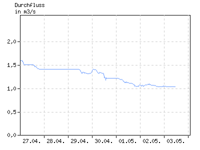
Durchfluss in m³/s
| 01:00 | 04:00 | 07:00 | 10:00 | 13:00 | 16:00 | 19:00 | 22:00 | |
|---|---|---|---|---|---|---|---|---|
| 21.04. | 2,886 | 2,883 | 2,743 | 2,593 | 2,457 | 2,305 | 2,163 | 2,163 |
| 22.04. | 2,054 | 2,053 | 1,944 | 1,905 | 1,823 | 1,823 | 1,719 | 1,714 |
| 23.04. | 1,714 | 1,713 | 1,713 | 1,713 | 1,664 | 1,616 | 1,699 | 1,713 |
| 24.04. | 1,713 | 1,713 | 1,684 | 1,603 | 1,603 | 1,603 | 1,603 | 1,603 |
| 25.04. | 1,603 | 1,603 | 1,603 | 1,603 | 1,603 | 1,602 | 1,603 | 1,603 |
| 26.04. | 1,603 | 1,603 | 1,603 | 1,603 | 1,589 | 1,515 | 1,510 | 1,574 |
| 27.04. | 1,597 | k.A. | k.A. | k.A. | k.A. | k.A. | k.A. | k.A. |
Abgabepegel
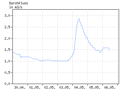
Durchfluss in m³/s
| 01:00 | 04:00 | 07:00 | 10:00 | 13:00 | 16:00 | 19:00 | 22:00 | |
|---|---|---|---|---|---|---|---|---|
| 21.04. | 2,853 | 2,850 | 2,710 | 2,560 | 2,424 | 2,272 | 2,130 | 2,130 |
| 22.04. | 2,021 | 2,020 | 1,911 | 1,872 | 1,790 | 1,790 | 1,686 | 1,681 |
| 23.04. | 1,681 | 1,680 | 1,680 | 1,680 | 1,631 | 1,583 | 1,666 | 1,680 |
| 24.04. | 1,680 | 1,680 | 1,651 | 1,570 | 1,570 | 1,570 | 1,570 | 1,570 |
| 25.04. | 1,570 | 1,570 | 1,570 | 1,570 | 1,570 | 1,569 | 1,570 | 1,570 |
| 26.04. | 1,570 | 1,570 | 1,570 | 1,570 | 1,556 | 1,482 | 1,477 | 1,541 |
| 27.04. | 1,564 | k.A. | k.A. | k.A. | k.A. | k.A. | k.A. | k.A. |
Stauanlage
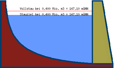
| Teilstauraum | Staulamelle einzeln [Mio. m³] |
Stauinhalt summarisch [Mio. m³] |
|---|---|---|
| Totraum | 0,000 | 0,000 |
| Reserveraum | 0,250 | 0,250 |
| Betriebsraum | 0,150 | 0,400 |
| gewöhnlicher Hochwasser- rückhalteraum |
0,000 | 0,400 |
Beckeninhalt in Mio m³
| 01:00 | 04:00 | 07:00 | 10:00 | 13:00 | 16:00 | 19:00 | 22:00 | |
|---|---|---|---|---|---|---|---|---|
| 21.04. | 0,415 | 0,415 | 0,412 | 0,409 | 0,406 | 0,403 | 0,400 | 0,400 |
| 22.04. | 0,397 | 0,397 | 0,394 | 0,394 | 0,391 | 0,391 | 0,388 | 0,388 |
| 23.04. | 0,388 | 0,388 | 0,388 | 0,388 | 0,387 | 0,385 | 0,388 | 0,388 |
| 24.04. | 0,388 | 0,388 | 0,387 | 0,385 | 0,385 | 0,385 | 0,385 | 0,385 |
| 25.04. | 0,385 | 0,385 | 0,385 | 0,385 | 0,385 | 0,385 | 0,385 | 0,385 |
| 26.04. | 0,385 | 0,385 | 0,385 | 0,385 | 0,385 | 0,383 | 0,382 | 0,384 |
| 27.04. | 0,385 | k.A. | k.A. | k.A. | k.A. | k.A. | k.A. | k.A. |
Wasserstand in müNN
| 01:00 | 04:00 | 07:00 | 10:00 | 13:00 | 16:00 | 19:00 | 22:00 | |
|---|---|---|---|---|---|---|---|---|
| 21.04. | 147,15 | 147,15 | 147,14 | 147,13 | 147,12 | 147,11 | 147,10 | 147,10 |
| 22.04. | 147,09 | 147,09 | 147,08 | 147,08 | 147,07 | 147,07 | 147,06 | 147,06 |
| 23.04. | 147,06 | 147,06 | 147,06 | 147,06 | 147,06 | 147,05 | 147,06 | 147,06 |
| 24.04. | 147,06 | 147,06 | 147,06 | 147,05 | 147,05 | 147,05 | 147,05 | 147,05 |
| 25.04. | 147,05 | 147,05 | 147,05 | 147,05 | 147,05 | 147,05 | 147,05 | 147,05 |
| 26.04. | 147,05 | 147,05 | 147,05 | 147,05 | 147,05 | 147,04 | 147,04 | 147,05 |
| 27.04. | 147,05 | k.A. | k.A. | k.A. | k.A. | k.A. | k.A. | k.A. |